By Scott Havens
Life as a weather station
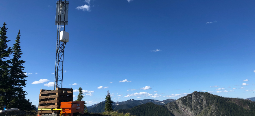
Sometimes I wonder what it would be like to be a weather station. I imagine myself on top of a mountain, sitting quietly, observing the weather and looking out at all the other snowy peaks. Being in a storm would be thrilling, snow blowing sideways as the wind tries to tip me over. Every hour, I’d let the outside world know I exist by sending my observations to the internet. Maybe I’m connected through a satellite, the data bounces up to space, back to a datacenter or three, then to a server that is waiting for my input. It’s a tireless and lonely job, and I’d have to sit there day and night for years. Many people are reliant on the data I’m collecting, but few know the trials and tribulations I go through to keep people informed. I’m often overlooked, the data shows up on your phone telling you that it’s 30 degrees now, but most never understand what it takes to get that one value. Would anyone notice if I weren’t there anymore?
SNOTEL is special
One of the largest weather station networks in the US is run by the USDA Natural Resources Conservation Service (NRCS). The network spans 12 western states, including Alaska, and has around 900 weather stations focused on collecting data from high-elevation snowpacks. Many people know it as SNOTEL or Snow Telemetry. SNOTEL sites are special because they measure the Snow Water Equivalent (SWE) of the entire snowpack using a large fluid-filled pillow. They also record snow depth, precipitation and temperature, with newer sites measuring more meteorological variables.
These measurements have been recorded at some sites for over 30 years. With that amount of data, we can see long-term trends in snowpack evolution, melt and year-to-year changes. The dataset from SNOTEL is some of the richest in the US and has even been used to validate and calibrate many weather forecast models. The SNOTEL program is the best bang for the buck, with 100x return on investment [1] for their annual $17 million budget for 2024 [2].
Mountain snowmelt accounts for approximately 75% of the water supply in the western US [3]. Using the 30+ year records from multiple sites, NRCS produces water supply forecasts, where downstream users make critical agricultural decisions for over 12 million acres, approximately 25% of the total US Agricultural GDP [1]. While agriculture is the primary focus of the SNOTEL network, the weather stations are used in many public safety organizations like flood forecasting, fire weather forecasting, drought monitoring, hydropower, transportation and avalanche forecasting.
While the primary user group for SNOTEL is agriculture, the hourly snow data from the weather stations is invaluable for avalanche forecasting. Avalanche forecasters use weather stations to make informed analyses of how much snow has fallen over complicated mountainous terrain. A large percentage of these observations are from SNOTEL stations.
Weather data for avalanche forecasting
The National Avalanche Center (NAC) built the Avalanche Forecast Platform (AFP) to standardize avalanche forecast products for US avalanche centers. Part of the platform is an interactive weather station map where forecasters and the public can access the weather station data in their forecast area. Currently, these maps display data from 1,178 weather stations, including 392 SNOTEL sites, 52 from the Northwest Avalanche Center (NWAC) and 734 from Mesowest/Synoptic Data [4].
| Variable | Mesowest | NWAC | Snotel | Total | % Snotel |
| Snow depth | 159 | 29 | 358 | 546 | 65.6% |
| Snow water equivalent | 26 | 0 | 371 | 397 | 93.5% |
| Precipitation accumulated | 261 | 0 | 387 | 648 | 59.7% |
| Any precipitation | 430 | 20 | 387 | 837 | 46.2% |
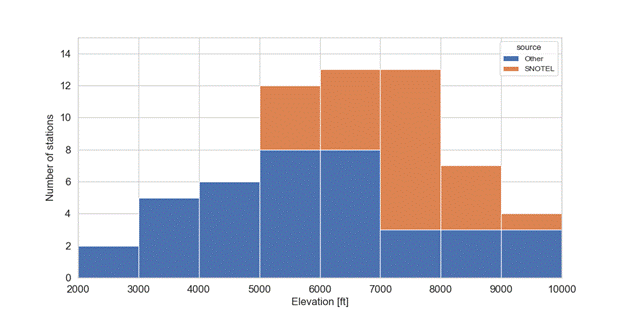
Weather station map sites that measure snow data
Although snow depth, SWE and precipitation are foundational factors used to assess snowpack loading, they are measured by less than half of all weather stations. Furthermore, because SWE is difficult to measure and requires significant infrastructure and maintenance, avalanche operations cannot afford them. SNOTEL stations account for 93% of available SWE data.
Measuring precipitation during winter is challenging, often resulting in significant data uncertainty due to the complexity of capturing and accurately weighing snowfall. Accurate precipitation measurements require robust infrastructure and maintenance, limiting their implementation. Snow depth is a simpler measurement but still demands proper installation and site upkeep. Despite being relatively straightforward, more than 65% of snow depth data relies on SNOTEL stations.
Losing SNOTEL stations
As the current administration begins to reduce the federal workforce, there is a serious threat that SNOTEL sites and their data could change dramatically. The greatest impact would be on the farmers and ranchers who rely on the mountain water supply. The avalanche forecasting industry would also be seriously impacted by the data loss. Avalanche forecasts are meant to inform and educate the public about possible avalanche hazards. The uncertainty in the forecast product relies on weather and snowpack observations. If either of those is reduced, then the uncertainty in the forecast goes up. It all comes down to data.
What would happen if SNOTEL sites start to disappear or fail to report? Worse yet, what if they are privatized to a company that wants to charge money to get access to public safety data?
Imagine it’s 4 am in Ketchum, Idaho, the coffee is brewing, and it’s been snowing hard for the last two days. A Sawtooth Avalanche Center forecaster sits down at the computer to start piecing together what is happening in the mountains. The forecaster pulls up weather station data across the four forecast zones, totaling 3,261 square miles, to get a glimpse of how much snow has fallen. While there is always uncertainty in the forecast, this data reduces it and helps formulate how the snowpack may react for the rest of the storm.
If the SNOTEL sites no longer report data, the morning routine will be drastically different. In this case, instead of sitting down to 24 weather stations measuring snow depth above 7,000 ft, there would be nine, and hardly any of these measure SWE – the most critical metric for estimating snowpack loading. Nine snow depth measurements to understand what is happening across four large mountain ranges. How does the forecaster extrapolate the 9 point measurements across such a large area? How will they communicate to the public the risk of avalanches given limited data? As a backcountry user, how will the increased uncertainty affect the way I make decisions traveling in the backcountry?
Weather stations measuring snow depth in the Sawtooth Avalanche Center area. Most higher elevation measurements are from SNOTEL. Without SNOTEL, there would only be 9 stations above 7,000 ft.
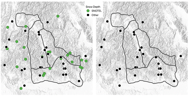
Weather stations with snow depth sensors at SNOTEL and other sites in the Sawtooth Avalanche Center forecast area. Left: The current data available. Right: Data available without SNOTEL.
Backcountry use has skyrocketed over the past 5 to 10 years, with more and more users accessing the backcountry on foot or by motorized means. Over the past 20 years, there has been an average of 25 avalanche-related fatalities each year [5], with a downward trend. Why there are fewer fatalities with more users recreating is for a completely different article, but the two have not risen equally [6]. What we can say is that public avalanche forecasts reach millions of users each year and play an outsized role in the reduction of the avalanche fatality rate.
The future
Weather data is one of the cornerstones of avalanche forecasting. While data may still be limited in some locations, avalanche forecasters have a deep understanding of their zones and are vigilant in getting observations that help them to provide the best possible avalanche forecast. However, if critical weather and snowpack data were to go away, the future of avalanche forecasting is uncertain. The data provided by SNOTEL is unique to the US and is one that we should all be grateful for and proud of. It’s the largest snow weather station network in the world and it impacts nearly everyone in the western US. The SNOTEL network is too important to be a victim of budget cuts and layoffs.
[1] Economic Research Service, USDA, 2023.
[2] NRCS SNOTEL budget https://www.usda.gov/sites/default/files/documents/29-2024-NRCS.pdf
[3] Li, Dongyue, et. al, ‘How Much Runoff Originates as Snow in the western United States, and how will that Change in the Future?’, 2017.
[4] Synoptic Data https://synopticdata.com/
[5] CAIC https://avalanche.state.co.us/accidents/statistics-and-reporting
[6] Birkland et al 2018 https://avalanche.org/wp-content/uploads/2018/07/17_WEM_Birkeland_etal_AvFatalities.pdf